- Along the top, Query and Link Display
- Links From previous entrys by users
- Followed by 2 independent PDF Viewers
- Top PDF Viewer hold the current Assessor MAP Page
- Followed by the recorded Map Display
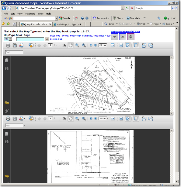
This page automatically looks up the assessors Map images for a Property PID or Assessors Parcel Number, APN. The PID argument is sent in the URL. It is
placed on the top AdobePDF® Viewer. You can scan the Assessor Page for Recorded Map ID's. These ID's have a map type prefix and a Book-Page number.
Select the Map type from the dropdown. Then enter the ID into the Book-Page
The Recorded Map page has three main parts:
|
|
Recorded map consist of several document types.
| RS, S, OS | Record of Survey/Official Survey; Corner Record |
| PM or P.M. or P | Parcel Map |
| RM or R.M. | Record Map |
| AD | Assessment District Diagrams (Special Taxing Districts) |
Official Recorded Maps and the Assessor's Maps
I will provide a brief description on the evolution of record maps over the years. Prior to the 1890's official recorded maps (Subdivisions, Ranchos, etc.) were filed by Rack and Pull. They were literally numbered and placed on drawing hanging rack stand (Rack) and individual clamps (Pull) thus a record map would be identified as Rack 1, Pull 1. There are only 2 Racks identified covering maps produced in the early 1880's through the 1900's and before the adoption of the Subdivision Map Act.
With the adoption of the Subdivision Map Act, and prior to circa 1998, official record maps were filed by Official Subdivision Maps (R.M.), Official Parcel Maps (P.M.), and Official Survey Maps (O.S.) which later came to be, and include, Record of Surveys (R.S.). Please note that Condominiums are typically included with Official Subdivision Maps (R.M.).
Each type of official maps was filed by Book and Page and like the example from above, Celeste Estates, R.M. Bk13, Pg22 is an Official Subdivision Map (R.M.) filed under Book 13 Page 22. Don't let the Page 22 mislead you; this is most likely to contain multiple map sheets. In 1998 through the present date official maps accepted the year recorded and the Book identifier thus the Map of the Buck Center Unit 2, was filed under R.M. Book 1999 Pg.80 (R.M. Bk.1999 Pg.80).
Other samples of references to official maps found on Assessor's Map Sheets:
Please note that all do not follow convention exactly, but can be easily interpreted.
| O.S.26-6 | Official Survey Map |
| P22-36 | Official Parcel Map |
| P.M.5-65 | Official Parcel Map |
| RS04-132 | Official Survey Map (Record of Survey) |
| OS 16-20 | Official Survey Map |
| R.M. Bk.1999-Pg.75 | Official Subdivision Map |
SSubd. BOOK 2 PAGE 3 = Rack 2 Pull 3 (East Part Rancho de Novato filed 1888)
Special case to naming convention in Assessor Map Sheet: Beginning in 1998 to 2007, books were named for the fiscal year, rather than by a three-digit book names (001-026). In the Assessor Map sheets, these are noted in the 'tic' margins with the trailing 2 digits (e.g., 98, 99, 01, 02, etc). So RS2003-023 would be noted as RS03-23.
Special note for Record Maps: All documents prior to 1998 use a 3 or digit book folder (e.g., 003, 005), and this is repeated within the document name, followed by a 3 digit page reference (e.g., PM003-010, RM005-009). This refers to the Book number padded with 0s. Official Surveys also use a 3-digit folder, but the book reference in the document name only has 2 digits (e.g., Official Survey\003\RS03-009). If an automated method is used to parse a document name entered from Assessor Map Sheet, care must be taken to account for this anomaly.